Notes
Sort by:| Metadata | Start Date | End Date | Comment |
|---|---|---|---|
|
RS03AXBS-LJ03A-11-OPTAAC303 |
There is no pressure variable in the .nc files. This should be a coordinate. By Lori Garzio, on 12/13/19 |
||
|
RS03AXBS-LJ03A-11-OPTAAC303 |
Missing data at the end of deployments 2 and 3 should be annotated. By Lori Garzio, on 12/13/19 |
||
|
RS03AXBS-LJ03A-11-OPTAAC303 Deployment: 2 |
Suspect data - lots of noise and negative values By Lori Garzio, on 12/13/19 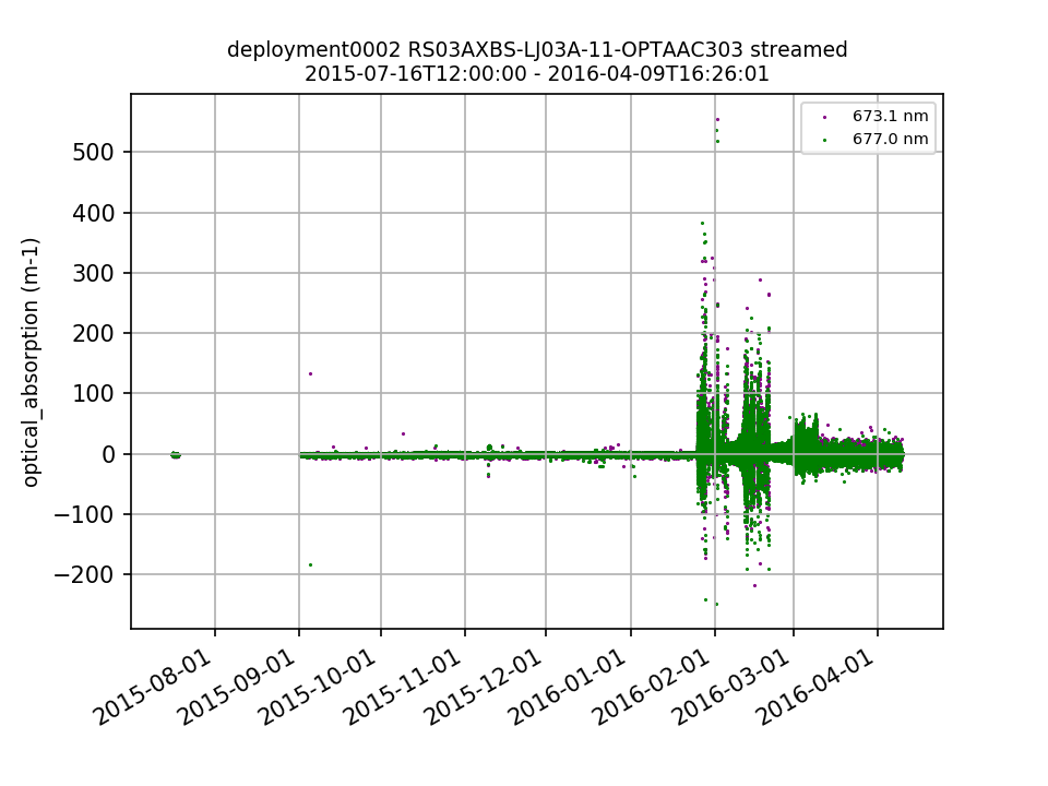 |
||
|
RS03AXBS-LJ03A-11-OPTAAC303 Deployment: 3 |
61% of beam attenuation and 84% optical_absorption values for this deployment are NaNs, fill values, outside of global ranges, or outliers (+/- 5 SD) By Lori Garzio, on 12/13/19  |
||
|
RS01SLBS-LJ01A-10-ADCPTE101 |
The .nc files for deployments 1-3 are missing the coordinates pressure, lat and lon. By Lori Garzio, on 12/16/19 |
||
|
RS01SLBS-LJ01A-10-ADCPTE101 |
bin_depths are incorrect for deployments 1-3. The bin_depth ranges are about 2475 - 2930 m for all three deployments. By Lori Garzio, on 12/16/19 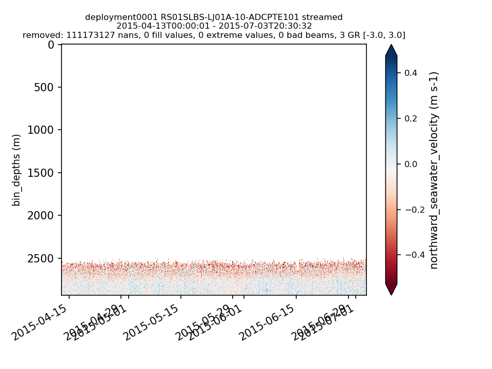 |
||
|
RS01SLBS-LJ01A-10-ADCPTE101 |
40-55% of seawater velocities for deployments 1-3 are NaNs, outside of global ranges, or outliers (+/- 5 SD). By Lori Garzio, on 12/16/19 |
||
|
RS03AXBS-LJ03A-10-ADCPTE303 Deployment: 1 |
Missing data for deployment 1 should be annotated. By Lori Garzio, on 12/16/19 |
||
|
RS03AXBS-LJ03A-10-ADCPTE303 |
The .nc files for deployments 1-3 are missing the coordinates pressure, lat and lon. By Lori Garzio, on 12/16/19 |
||
|
RS03AXBS-LJ03A-10-ADCPTE303 |
bin_depths are incorrect for deployments 1-3. The bin_depth ranges are about 2100 - 2700 m for all three deployments. By Lori Garzio, on 12/16/19 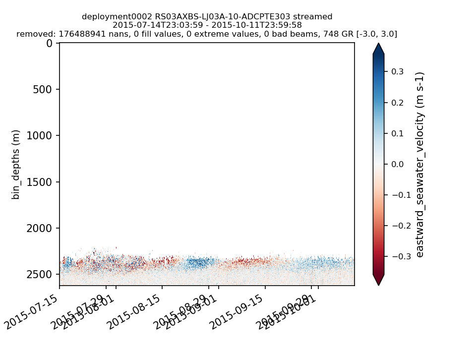 |
||
|
RS03AXBS-LJ03A-10-ADCPTE303 |
40-70% of seawater velocities for deployments 1-3 are NaNs, outside of global ranges, or outliers (+/- 5 SD). By Lori Garzio, on 12/16/19 |
||
|
RS01SUM2-MJ01B-12-ADCPSK101 Deployment: 1 |
The .nc files for deployment 1 are missing the coordinates pressure, lat and lon. By Lori Garzio, on 12/18/19 |
||
|
RS01SUM2-MJ01B-12-ADCPSK101 Deployment: 1 |
It looks like the bin_depths changed in March 2015, after which there is a lot of noise in the upper 300m of the water column. By Lori Garzio, on 12/18/19 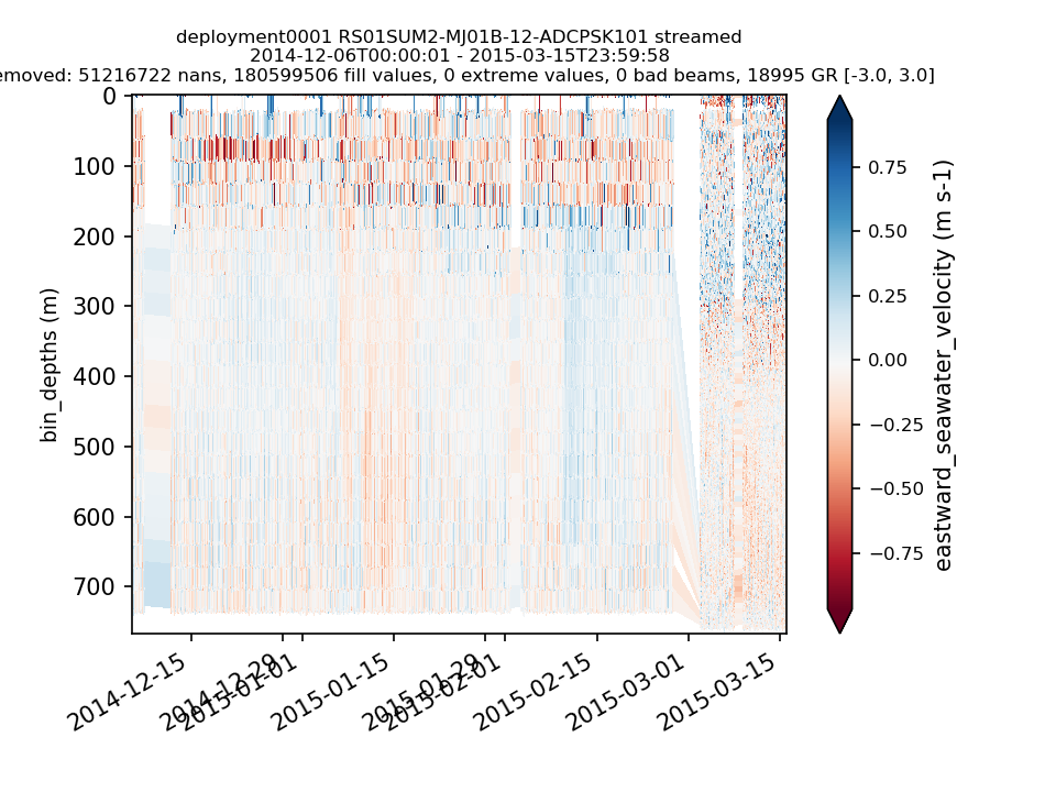 |
||
|
RS01SUM2-MJ01B-12-ADCPSK101 Deployment: 1 |
Approximately 50% of the seawater velocities for deployment 1 are NaNs, outside of global ranges, or outliers (+/- 5 SD) By Lori Garzio, on 12/18/19 |
||
|
GI05MOAS-GL485-04-CTDGVM000 |
98% of sci_seawater_density values are NaNs - the only data available are near the surface. Lat and lon are parameters used in the data product algorithm, so I think this got messed up with the re-organization of the glider lat/lon parameters. See Redmine ticket #14486 By Lori Garzio, on 1/13/20 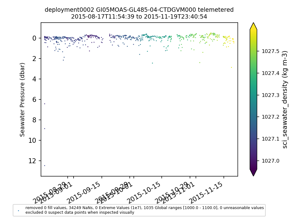 |
||
|
GI05MOAS-GL485-02-DOSTAM000 |
98% of sci_abs_oxygen values are NaNs - the only data available are near the surface. Lat and lon are parameters used in the data product algorithm, so I think this got messed up with the re-organization of the glider lat/lon parameters. See Redmine ticket #14486 By Lori Garzio, on 1/13/20 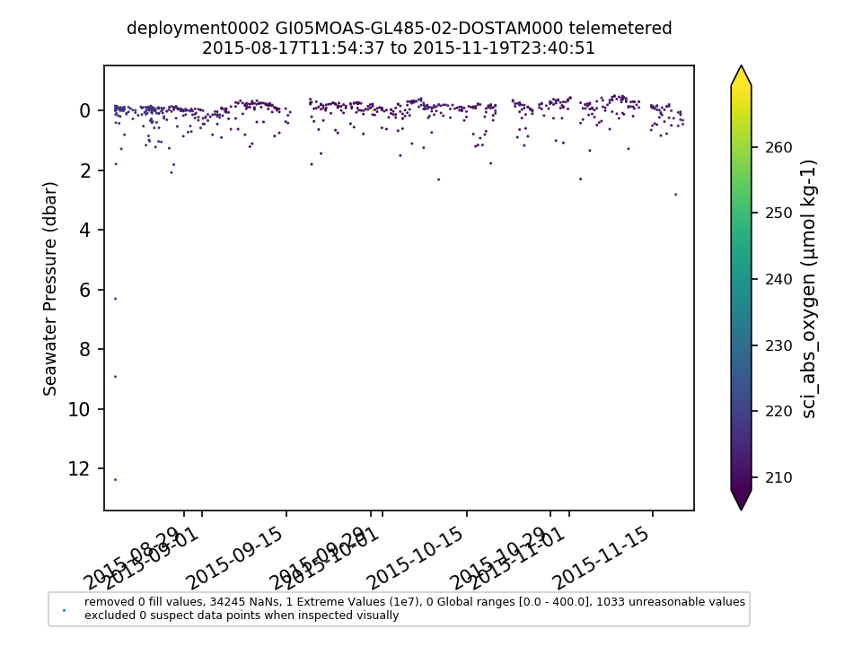 |
||
|
GI05MOAS-GL493-04-CTDGVM000 |
98% of sci_seawater_density values are NaNs - the only data available are near the surface. Lat and lon are parameters used in the data product algorithm, so I think this got messed up with the re-organization of the glider lat/lon parameters. See Redmine ticket #14486 By Lori Garzio, on 1/13/20  |
||
|
GI05MOAS-GL493-02-DOSTAM000 |
98% of sci_abs_oxygen values are NaNs - the only data available are near the surface. Lat and lon are parameters used in the data product algorithm, so I think this got messed up with the re-organization of the glider lat/lon parameters. See Redmine ticket #14486 By Lori Garzio, on 1/13/20 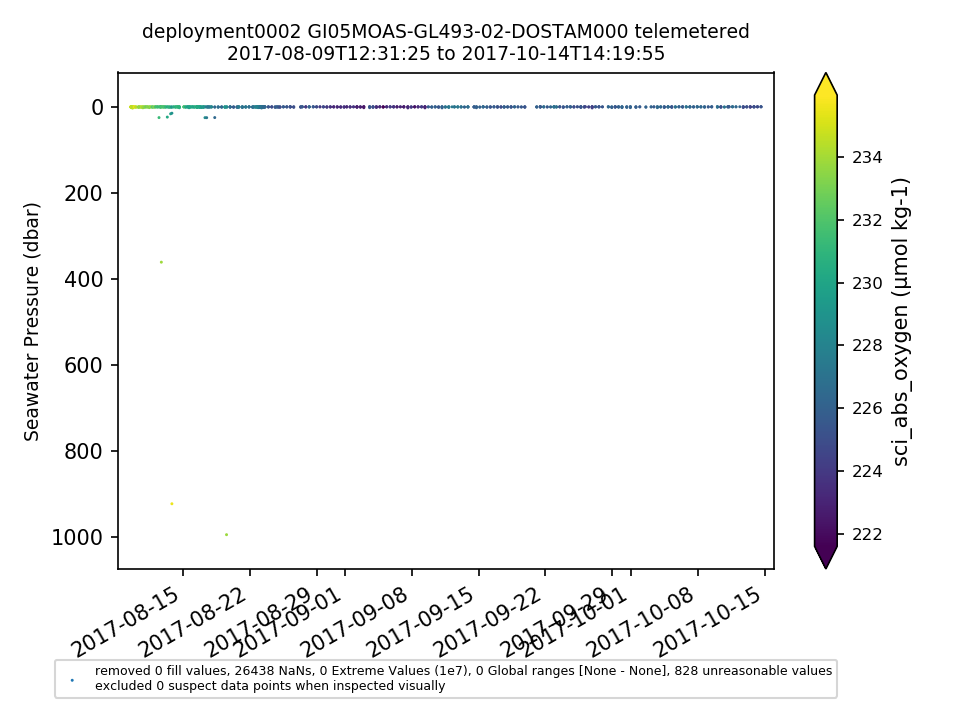 |
||
|
GI05MOAS-GL495-04-CTDGVM000 |
98% of sci_seawater_density values are NaNs - the only data available are near the surface. Lat and lon are parameters used in the data product algorithm, so I think this got messed up with the re-organization of the glider lat/lon parameters. See Redmine ticket #14486 By Lori Garzio, on 1/13/20 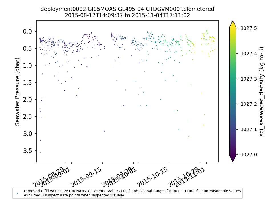 |
||
|
GI05MOAS-GL495-02-DOSTAM000 |
98% of sci_abs_oxygen values are NaNs - the only data available are near the surface. Lat and lon are parameters used in the data product algorithm, so I think this got messed up with the re-organization of the glider lat/lon parameters. See Redmine ticket #14486 By Lori Garzio, on 1/13/20 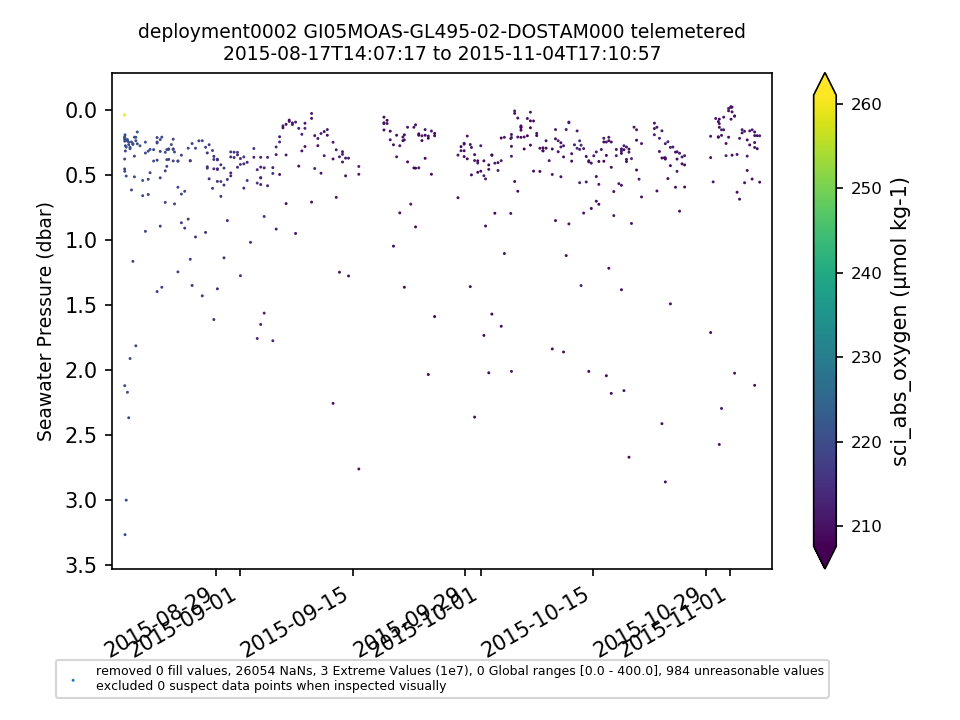 |