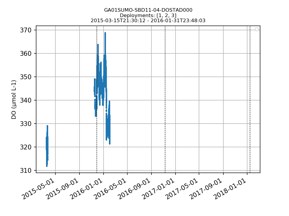
Dissolved Oxygen
- Reference Designator
- GA01SUMO-SBD11-04-DOSTAD000
- Review Status
- Review Complete
- Note
- Biofouling affected data quality.
- Depth
- 1m
- Class
- DOSTA (Dissolved Oxygen Stable Response)
- Make / Model
- Aanderaa / Optode 4831
Dataset Reviews Last processed: 1/12/19, 12:01 AM
| Dep. | Preferred Method | Stream | DD | FD | SG | EG | Gaps | GD | TS | Rate (s) | Pressure Comp. | Time Order | Valid Data | Missing Data | Data Comp. | Missing Coords. | Review |
|---|---|---|---|---|---|---|---|---|---|---|---|---|---|---|---|---|---|
| 1 | recovered_host | 257 | 8 | 0 | 248 | 0 | 0 | 52,143 | 2 | 1 / | 1 | 1 | Complete | ||||
| 2 | recovered_host | 361 | 361 | 0 | 0 | 0 | 0 | 2,977,255 | 2 | 1 / | Complete | ||||||
| 3 | recovered_host | 445 | 427 | 0 | 0 | 5 | 20 | 3,451,809 | 2 | 0 / | Complete |
Test Notes
- no other streams for comparison
Data Coverage
| Deployment: | 1 | 2 | 3 |
|---|---|---|---|
| 3% | 100% | 96% |
Lat/Lon Differences (km)
| Deployment: | 1 | 2 | 3 |
|---|---|---|---|
| 1 | 0.00 | ||
| 2 | 10.69 | 0.00 | |
| 3 | 1.25 | 11.91 | 0.00 |
Example Composite Data Plot

System Annotations Show
| Metadata | Start Date | End Date | Comment |
|---|---|---|---|
|
GA01SUMO |
3/15/15, 5:25 PM | 11/26/15, 5:08 AM |
Deployment 1: Buoy log files showed that seawater was first detected inside the buoy well on 3/26/2015. Both leak detectors showed increasing presence of water over the period of deployment. Upon recovery of the mooring, no external damage was visible and the buoy did not appear to be floating lower than normal. Id: 653 By: lgarzio |
|
GA01SUMO-SBD11 |
3/15/15, 5:25 PM | 11/26/15, 5:08 AM |
Deployment 1: Upon recovery, the bottom of the buoy was heavily biofouled with gooseneck barnacles. The barnacle coverage likely caused imporper sea water flushing at the location of the intakes and sensor faces for the subsurface instruments. Id: 654 By: lgarzio |
|
GA01SUMO-SBD11-04-DOSTAD000 |
3/15/15, 5:25 PM | 11/26/15, 5:08 AM |
Deployment 1: A gooseneck barnacle was attached to the sensor membrane at recovery. Id: 656 By: lgarzio |
|
GA01SUMO-SBD11 |
11/14/15, 4:06 PM | 11/8/16, 5:10 AM |
Deployment 2: Upon recovery, the bottom of the buoy was heavily biofouled with barnacles. Id: 663 By: lgarzio |
|
GA01SUMO-SBD11 |
10/26/16, 9:47 PM | 1/14/18, 5:24 AM |
Deployment 3: Upon recovery, the bottom of the buoy was heavily biofouled. Id: 385 By: lgarzio |
Review Notes
| Metadata | Start Date | End Date | Comment |
|---|---|---|---|
|
GA01SUMO-SBD11-04-DOSTAD000 |
Deployments 2 and 3: Dissolved oxygen concentrations in the beginning of both deployments seem reasonable, then quickly decline. It appears that the biofouling of the surface buoy negatively impacted the quality of the data for both deployments. I compared the instrument data to shipboard data from D0002 (nbp1510_010.cnv) and R0003 (at3903007.cnv). The shipboard CTD data are not available for the GA3 cruise - R0002 and D0003 (these files should be uploaded to alfresco). From the comparisons I was able to do, it appears that the instrument was recording values within a reasonable range at the beginning of the deployment, and unreasonably low values at the end of the deployment (compared to the shipboard CTD data). These data should be annotated as suspect. By Lori Garzio, on 2/22/19 |
||
|
GA01SUMO-SBD11-04-DOSTAD000 Deployment: 2 |
2/1/16, 12:00 AM | 11/8/16, 10:10 AM |
Data are unreasonable, likely due to biofouling (see other note). By Lori Garzio, on 2/22/19 |
|
GA01SUMO-SBD11-04-DOSTAD000 Deployment: 3 |
10/27/16, 1:47 AM | 1/14/18, 10:24 AM |
Data are unreasonable, likely due to biofouling (see other note). By Lori Garzio, on 2/22/19 |