CTD
- Reference Designator
- GP05MOAS-GL361-04-CTDGVM000
- Review Status
- Review Complete
- Note
- Depth
- 0 to 1,000m
- Class
- CTDGV (CTD Glider)
- Make / Model
- Sea-Bird / SBE Glider Payload CTD (GP-CTD)
Dataset Reviews Last processed: 3/3/20, 9:22 PM
| Dep. | Preferred Method | Stream | DD | FD | SG | EG | Gaps | GD | TS | Rate (s) | Pressure Comp. | Time Order | Valid Data | Missing Data | Data Comp. | Missing Coords. | Review |
|---|---|---|---|---|---|---|---|---|---|---|---|---|---|---|---|---|---|
| 1 | telemetered | 74 | 9 | 0 | 59 | 1 | 6 | 2,712 | 60 | 1000 / 988 | 1 | 1 | 2 | Complete |
Test Notes
- no other streams for comparison
- missing: ['lat', 'lon', 'pressure']
Data Coverage
| Deployment: | 1 |
|---|---|
| 12% |
Deployment Map

System Annotations Show
| Metadata | Start Date | End Date | Comment |
|---|---|---|---|
|
GP05MOAS-GL361 |
2/19/14, 7:00 PM | 3/4/14, 7:14 PM |
Glider went adrift and was not recovered. Only telemetered data are available. Id: 172 By: lgarzio |
Review Notes
| Metadata | Start Date | End Date | Comment |
|---|---|---|---|
|
GP05MOAS |
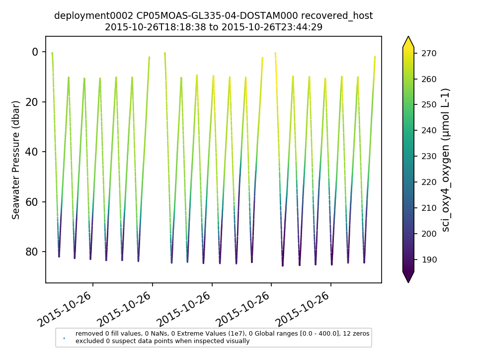
Glider optodes typically exhibit a sensor lag of 20-25 seconds. Example attached of several segments with consecutive down and up casts for CP05MOAS-GL335-04-DOSTAM000 on 10/26/2015 showing a typical measurement time lag. Profiles should be analyzed for individual time lags and data should be adjusted. OOI doesn't necessarily need to make the adjustment but users should be aware of the issue. By Lori Garzio, on 5/31/19 |
||
|
GP05MOAS-GL361 Deployment: 1 |
latitude and longitude are missing from all telemetered .nc files (Redmine #14657). By Lori Garzio, on 3/13/20 |
||
|
GP05MOAS-GL361-04-CTDGVM000 Deployment: 1 |
100% of sci_seawater_density values are NaNs By Lori Garzio, on 3/13/20 |
