Nitrate
- Reference Designator
- CE07SHSM-RID26-07-NUTNRB000
- Start Depth
- 7
- End Depth
- 7
- Location
- Near Surface Instrument Frame
- Current Status
- Review Complete
- M2M Example
- https://ooinet.oceanobservatories.org/api/m2m/12576/sensor/inv/CE07SHSM/RID26/07-NUTNRB000/metadata
| Method | Data Stream | Content | Type | |
|---|---|---|---|---|
| recovered_host | nutnr_b_dcl_conc_instrument_recovered | Data Products | Report M2M Stats | Science |
| recovered_host | nutnr_b_dcl_conc_metadata_recovered | Metadata | Report M2M | Engineering |
| recovered_host | nutnr_b_dcl_dark_conc_instrument_recovered | Dark Sample Data Products | Report M2M Stats | Science |
| recovered_host | nutnr_b_dcl_full_instrument_recovered | Data Products | Report M2M Stats | Science |
| recovered_inst | nutnr_b_dark_instrument_recovered | Dark Sample Data Products | Report M2M Stats | Science |
| recovered_inst | nutnr_b_instrument_recovered | Data Products | Report M2M Stats | Science |
| recovered_inst | nutnr_b_metadata_recovered | Metadata | Report M2M | Engineering |
| telemetered | nutnr_b_dcl_conc_instrument | Data Products | Report M2M Stats | Science |
| telemetered | nutnr_b_dcl_conc_metadata | Metadata | Report M2M | Engineering |
| telemetered | nutnr_b_dcl_dark_conc_instrument | Dark Sample Data Products | Report M2M Stats | Science |
| telemetered | nutnr_b_dcl_full_instrument | Data Products | Report M2M Stats | Science |
| Deployment | Cruise | Start Date | Stop Date | Mooring Asset | Node Asset | Sensor Asset | Latitude | Longitude | Deployment Depth | Water Depth |
|---|---|---|---|---|---|---|---|---|---|---|
| 1 Review | OC1503D | 04/05/2015 | 09/23/2015 | CGMCE-07SHSM-00001 | CGINS-NUTNRB-00253 | 46.9861 | -124.566 | 7 | 87 | |
| 2 Review | OC1510A | 10/13/2015 | 05/13/2016 | CGMCE-07SHSM-00002 | CGINS-NUTNRB-00288 | 46.9875 | -124.569 | 7 | 87 | |
| 3 Review | TN-342 | 05/05/2016 | 09/27/2016 | CGMCE-07SHSM-00003 | CGINS-NUTNRB-00255 | 46.9895 | -124.569 | 7 | 87 | |
| 4 Review | AT37-03 | 09/20/2016 | 04/13/2017 | CGMCE-07SHSM-00004 | CGINS-NUTNRB-00244 | 46.9859 | -124.566 | 7 | 87 | |
| 5 Review | SKQ201704S | 04/11/2017 | 10/06/2017 | CGMCE-07SHSM-00005 | CGINS-NUTNRB-00264 | 46.9882 | -124.567 | 7 | 89 | |
| 6 Review | SKQ201715S | 10/03/2017 | 03/29/2018 | CGMCE-07SHSM-00006 | CGINS-NUTNRB-00289 | 46.9852 | -124.564 | 7 | 87 | |
| 7 Review | SKQ201808S | 03/25/2018 | 09/20/2018 | CGMCE-07SHSM-00007 | CGINS-NUTNRB-01128 | 46.9881 | -124.568 | 7 | 87 | |
| 8 Review | SR1813 | 09/18/2018 | 04/26/2019 | CGMCE-07SHSM-00008 | CGINS-NUTNRB-01059 | 46.9835 | -124.564 | 7 | 87 | |
| 9 Review | SKQ201910S | 04/24/2019 | 10/12/2019 | CGMCE-07SHSM-00009 | CGINS-NUTNRB-01057 | 46.9878 | -124.568 | 7 | 87 | |
| 10 Review | SKQ201921S | 10/10/2019 | CGMCE-07SHSM-00010 | CGINS-NUTNRB-01059 | 46.9841 | -124.566 | 7 | 87 |
| Metadata | Start Date | End Date | Comment |
|---|---|---|---|
|
CE07SHSM-RID26-07-NUTNRB000 |
Annotation ID 1412 should be updated when the parser is complete and the data from the new instruments is ingested. By Lori Garzio, on 7/23/19 |
||
|
CE07SHSM-RID26-07-NUTNRB000 |
There is no pressure variable in the .nc files. This should be a coordinate. By Lori Garzio, on 7/23/19 |
||
|
CE07SHSM-RID26-07-NUTNRB000 |
Data generally look suspect for all deployments of this instrument (the ISUS model) because of the prevalence of negative values. The dataset should be annotated if there is a known issue with this instrument to inform users if all or some data should be considered suspect. By Lori Garzio, on 7/23/19 |
||
|
CE07SHSM-RID26-07-NUTNRB000 Deployment: 1 |
4/15/15, 5:15 PM | 9/23/15, 3:08 PM |
Suspect data - 100% of the values for nitrate_concentration are outside of global ranges (65-95 umol L-1) By Lori Garzio, on 7/23/19  |
|
CE07SHSM-RID26-07-NUTNRB000 Deployment: 2 |
10/13/15, 5:02 PM | 5/13/16, 10:15 PM |
Suspect data - 38% and 31% of the values for salinity_corrected_nitrate and nitrate_concentration are outside of global ranges. By Lori Garzio, on 7/23/19  |
|
CE07SHSM-RID26-07-NUTNRB000 Deployment: 3 |
5/15/16, 12:00 AM | 9/27/16, 7:47 PM |
highly variable nitrate_concentration values a few weeks after deployment, including negative values - possible biofouling? By Lori Garzio, on 7/23/19  |
|
CE07SHSM-RID26-07-NUTNRB000 Deployment: 4 |
9/20/16, 10:27 PM | 4/13/17, 11:22 PM |
Suspect data - 78% of the values for salinity_corrected_nitrate are fill values or outside of global ranges By Lori Garzio, on 7/23/19 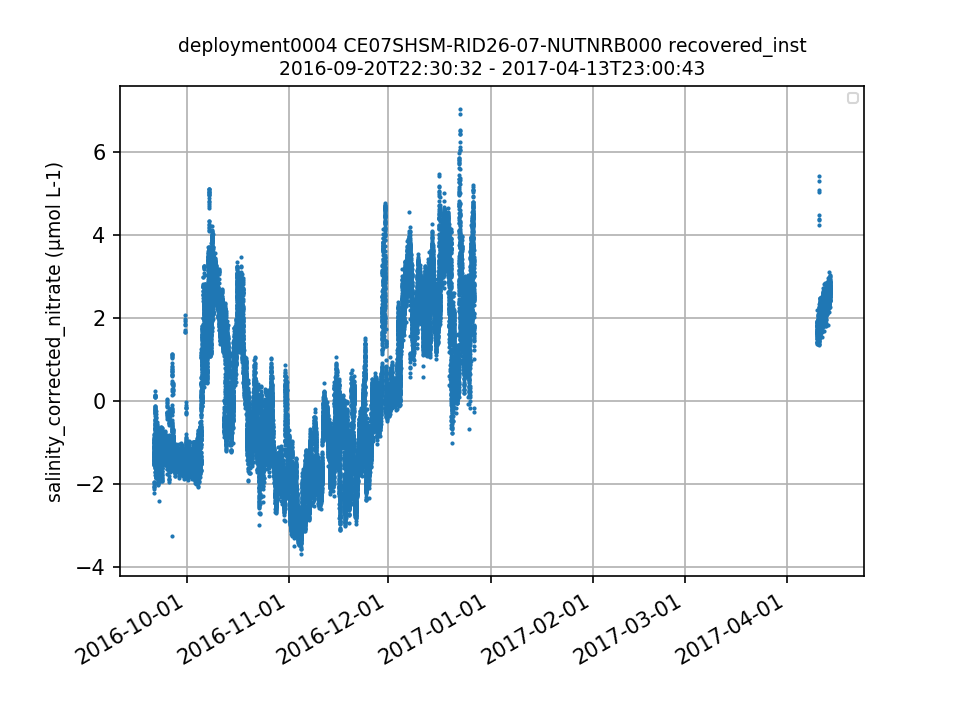 |
|
CE07SHSM-RID26-07-NUTNRB000 Deployment: 5 |
4/11/17, 5:51 PM | 10/6/17, 2:26 PM |
Suspect data - 85% and 44% of the values for salinity_corrected_nitrate and nitrate_concentration are outside of global ranges. By Lori Garzio, on 7/23/19 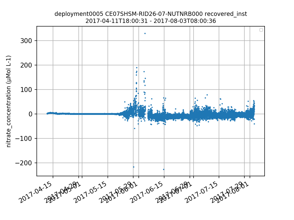 |
|
CE07SHSM-RID26-07-NUTNRB000 Deployment: 6 |
Only telemetered data are available for this deployment. Recovered data need to be ingested - the ingest csv indicates that the data weren't ingested because a new parser needs to be developed, but this dataset should still be the old ISUS data and can be ingested with the original parsers. By Lori Garzio, on 7/23/19 |
||
|
CE07SHSM-RID26-07-NUTNRB000 Deployment: 6 |
12/15/17, 12:00 AM | 3/29/18, 4:20 PM |
highly variable nitrate_concentration values towards the end of the deployment, including negative values - possible biofouling? By Lori Garzio, on 7/23/19 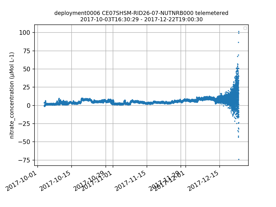 |
| Metadata | Start Date | End Date | Comment |
|---|---|---|---|
|
CE07SHSM |
12/1/17, 9:35 AM | 3/25/18, 3:09 PM |
Data loss due to a power system failure. The mooring stopped receiving power from photo voltaic panel 1 of 4 on Nov-2. By Nov-20, the mooring stopped receiving power from two more solar panels (PV2 & PV4) and one of two wind turbines (WT2). This indicates the Power System Controller (PSC) they connect to is failing. Mooring components will be shut down as the mooring loses the ability to recharge its batteries.
Id: 1237
By: crisien
|
|
CE07SHSM-RID26-07-NUTNRB000 |
12/22/17, 2:00 PM |
The Satlantic ISUS instrument has been discontinued, and all OOI ISUS units have been converted to the Sea-Bird SUNA model. A new data parser is in development, and any resulting data gaps will be filled once the parser has been delivered and the data are processed. Id: 1412 By: lgarzio |
|
|
CE07SHSM Method: telemetered |
5/13/20, 6:40 PM |
Due to a bug in the mooring telemetry system, data during this time range was not telemetered to shore. It was recorded on the mooring and instruments and will be available in the recovered data streams.
Id: 2185
By: wingardc
|