CTD
- Reference Designator
- GA02HYPM-WFP03-04-CTDPFL000
- Start Depth
- 2,600
- End Depth
- 5,023
- Location
- Wire Following Profiler Body
- Current Status
- Review Complete
- M2M Example
- https://ooinet.oceanobservatories.org/api/m2m/12576/sensor/inv/GA02HYPM/WFP03/04-CTDPFL000/metadata
| Method | Data Stream | Content | Type | |
|---|---|---|---|---|
| recovered_wfp | ctdpf_ckl_wfp_instrument_recovered | Data Products | Report M2M Stats | Science |
| recovered_wfp | ctdpf_ckl_wfp_metadata_recovered | Metadata | Report M2M | Engineering |
| telemetered | ctdpf_ckl_wfp_instrument | Data Products | Report M2M Stats | Science |
| telemetered | ctdpf_ckl_wfp_sio_mule_metadata | Metadata | Report M2M | Engineering |
| Deployment | Cruise | Start Date | Stop Date | Mooring Asset | Node Asset | Sensor Asset | Latitude | Longitude | Deployment Depth | Water Depth |
|---|---|---|---|---|---|---|---|---|---|---|
| 1 Review | AT26-30 | 03/16/2015 | 11/15/2015 | CGMGA-02HYPM-00001 | CGVEH-GWFPGX-10406 | CGINS-CTDPFL-00129 | -42.9817 | -42.4985 | 5116 | 5200 |
| 2 Review | NBP1510 | 11/16/2015 | 06/01/2016 | CGMGA-02HYPM-00002 | CGVEH-GWFPGX-45204 | CGINS-CTDPFL-00153 | -42.9808 | -42.5419 | 5015 | 5196 |
| 3 Review | NBP1609 | 10/29/2016 | 01/11/2018 | CGMGA-02HYPM-00003 | CGVEH-GWFPGX-10404 | CGINS-CTDPFL-00135 | -42.9781 | -42.4957 | 5013 | 5189 |
| Metadata | Start Date | End Date | Comment |
|---|---|---|---|
|
GA02HYPM-WFP03-04-CTDPFL000 |
Comparisons with shipboard CTD casts were done for D0001, D0002, and R0001. D0001: conductivity, density and salinity are lower for the platform compared to the shipboard CTD. D0002 and R0001: salinity is lower for the platform compared to the shipboard CTD. Further analysis using the shipboard water sampling data should be done. This is outside the scope of this project. By Lori Garzio, on 3/8/19 |
||
|
GA02HYPM |
I submitted a helpdesk question on 11/12/2018 regarding an offset between recovered and telemetered data for all global HYPMs: "There appears to be a substantial offset between data with the same timestamps from recovered_wfp and telemetered methods for all deployments of all global WFP CTDs, and I have included information from two representative deployments of two different profilers as examples. It looks like the values recorded for the first common timestamp are exactly the same, and as the profiler moves along in time the offset between the values recorded for the same timestamp become increasingly more offset. Then, the profiler reaches the end of the profile (either at its shallowest or deepest point), resets, and the pattern begins again. This is most easily seen in the pressure data, but there is an offset for all science parameters. Examples: The *_intersect.csv files attached contain data where recovered and telemetered timestamps intersect. For each timestamp and science parameter there are recorded values (from .nc files downloaded from the system) and the difference. For each parameter, the difference between the values at the bottom and top of the profiler's range are exactly zero, and (particularly for pressure) the differences steadily increase until they are reset at zero at the bottom/top of the profile. This pattern continues throughout the deployment. The plots attached are zoomed in to one upcast and one downcast, and highlight the offset in the data between the two methods." Redmine 13743 By Lori Garzio, on 8/2/19 |
||
|
GA02HYPM-WFP03-04-CTDPFL000 Deployment: 1 |
3/16/15, 7:00 PM | 11/15/15, 3:22 PM |
Too much variation in salinity - not seen in deployments 2 and 3 By Lori Garzio, on 8/5/19 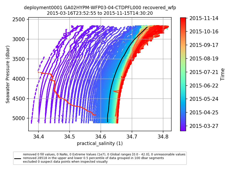 |
|
GA02HYPM Deployment: 2 |
5/23/16, 12:00 AM | 11/5/16, 12:00 AM |
Modify annotation ID 130 to indicate the time the mooring fell. According to the pressure data from the CTDMO, the mooring began to fall around 5/23/2016. Excluding data from final statistics. By Lori Garzio, on 1/3/19 |
|
GA02HYPM-WFP03-04-CTDPFL000 Deployment: 3 |
1/20/17, 12:00 AM | 1/22/17, 12:00 AM |
Suspect profile - low salinity. By Lori Garzio, on 8/5/19 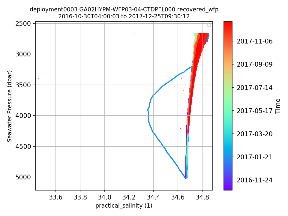 |
| Metadata | Start Date | End Date | Comment |
|---|---|---|---|
|
GA02HYPM |
11/16/15, 1:36 PM | 1/11/18, 10:09 AM |
Deployments 2 and 3: Data were not transmitted via satellite telemetry. Id: 374 By: lgarzio |
|
GA02HYPM |
11/16/15, 1:36 PM | 11/4/16, 8:00 PM |
Deployment 2: At the initial recovery attempt of this mooring in Nov 2016, it was determined that the mooring had fallen and was not recovered. During the following cruise in Jan 2018, the mooring was successfully recovered on 2018-01-15T09:30:00. Id: 130 By: lgarzio |