CTD (750 m)
- Reference Designator
- GP03FLMA-RIM01-02-CTDMOH049
- Start Depth
- 750
- End Depth
- 750
- Location
- Fixed on Inductive Wire
- Current Status
- Review Complete
- M2M Example
- https://ooinet.oceanobservatories.org/api/m2m/12576/sensor/inv/GP03FLMA/RIM01/02-CTDMOH049/metadata
| Method | Data Stream | Content | Type | |
|---|---|---|---|---|
| recovered_host | ctdmo_ghqr_offset_recovered | Offset Data | Report M2M | Engineering |
| recovered_host | ctdmo_ghqr_sio_mule_instrument | Data Products | Report M2M Stats | Science |
| recovered_inst | ctdmo_ghqr_instrument_recovered | Data Products | Report M2M Stats | Science |
| telemetered | ctdmo_ghqr_sio_mule_instrument | Data Products | Report M2M Stats | Science |
| telemetered | ctdmo_ghqr_sio_offset | Offset Data | Report M2M | Engineering |
| Deployment | Cruise | Start Date | Stop Date | Mooring Asset | Node Asset | Sensor Asset | Latitude | Longitude | Deployment Depth | Water Depth |
|---|---|---|---|---|---|---|---|---|---|---|
| 1 Review | MV-1309 | 07/21/2013 | 06/15/2014 | CGMGP-03FLMA-00001 | CGINS-CTDMOH-10226 | 49.9795 | -144.254 | 748 | 4127 | |
| 2 Review | MV-1404 | 06/17/2014 | 06/05/2015 | CGMGP-03FLMA-00002 | CGINS-CTDMOH-11683 | 49.9775 | -144.246 | 748 | 4237 | |
| 3 Review | TN-323 | 06/06/2015 | 06/28/2016 | CGMGP-03FLMA-00003 | CGINS-CTDMOH-10226 | 49.9767 | -144.246 | 767 | 4127 | |
| 4 Review | RB-16-05 | 07/01/2016 | 07/18/2017 | CGMGP-03FLMA-00004 | CGINS-CTDMOH-10228 | 49.9743 | -144.24 | 4127 | ||
| 5 Review | SR17-10 | 07/13/2017 | 07/27/2018 | CGMGP-03FLMA-00005 | CGINS-CTDMOH-11682 | 50.0229 | -144.361 | 4096 | ||
| 6 Review | SR1811 | 07/23/2018 | 09/29/2019 | CGMGP-03FLMA-00006 | CGINS-CTDMOH-13653 | 49.9761 | -144.246 | 4123 | ||
| 7 Review | SKQ201920S | 09/29/2019 | CGMGP-03FLMA-00007 | CGINS-CTDMOH-11683 | 50.0227 | -144.361 | 4103 |
| Metadata | Start Date | End Date | Comment |
|---|---|---|---|
|
GP03FLMA |
7/1/16, 1:07 AM | 7/27/18, 10:14 PM |
Deployments 4 and 5 don't have deployment depths defined in asset management. By Lori Garzio, on 1/3/19 |
|
GP03FLMA-RIM01-02-CTDMOH049 Deployment: 4 |
7/1/16, 1:07 AM | 7/18/17, 3:13 PM |
As confirmed with the pressure data, the instrument slid to approx. 930m at deployment and slid again to approx. 1020m on 2016-11-01 (annotation ID 149). Excluding this dataset from the final statistics. By Lori Garzio, on 1/8/19 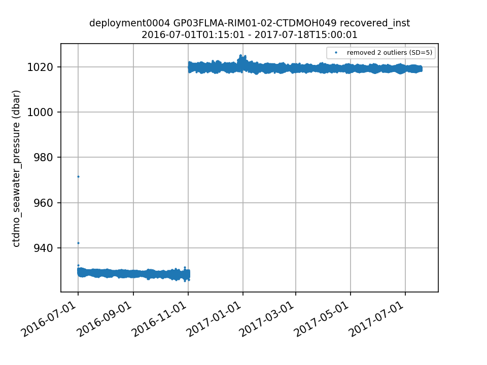 |
|
GP03FLMA Deployment: 5 |
7/13/17, 11:00 PM | 7/27/18, 10:14 PM |
The mooring was deployed 9 - 10 km from the location of the previous 4 deployments of this mooring. If this location is correct, the platform should be annotated to inform the users as to why the deployment location changed. By Lori Garzio, on 1/4/19 |
|
GP03FLMA-RIM01-02-CTDMOH049 Deployment: 5 |
7/26/18, 12:00 PM | 7/27/18, 10:14 PM |
Pressure (and density) increased suddenly at the end of the deployment. Excluding from final statistics. By Lori Garzio, on 1/8/19 |
| Metadata | Start Date | End Date | Comment |
|---|---|---|---|
|
GP03FLMA |
7/21/13, 6:44 PM | 6/14/14, 8:00 PM |
Deployment 1: Mooring was deployed 10-15m shallower than planned. Telemetered data are not available for this deployment. Id: 150 By: lgarzio |
|
GP03FLMA |
6/17/14, 2:00 AM | 6/4/15, 8:00 PM |
Deployment 2: Mooring was deployed 15-20m shallower than planned. Upon recovery of platform, biofouling was apparent on shallow CTDs. Id: 151 By: lgarzio |
|
GP03FLMA |
6/6/15, 6:40 PM | 6/28/16, 3:10 PM |
Deployment 3: Mooring was deployed 10-15m deeper than planned. Id: 152 By: lgarzio |
|
GP03FLMA |
6/30/16, 9:07 PM | 7/18/17, 11:13 AM |
Deployment 4: Mooring was deployed 10-15m deeper than planned. Id: 153 By: lgarzio |
|
GP03FLMA-RIM01-02-CTDMOH049 |
6/30/16, 9:15 PM | 7/18/17, 11:00 AM |
Deployment 4: Instrument's planned deployment depth was 750m, but it slid to approx. 930m at deployment and slid again to approx. 1020m on 2016-11-01. This was confirmed upon recovery of the mooring. Id: 149 By: lgarzio |
|
GP03FLMA |
7/13/17, 7:00 PM | 7/27/18, 6:14 PM |
Deployment 5: Telemetered data are not available for this deployment because gliders were not deployed. Id: 141 By: lgarzio |