Notes
Sort by:| Metadata | Start Date | End Date | Comment |
|---|---|---|---|
|
CP02PMCO-WFP01-03-CTDPFK000 Deployment: 1 |
6/28/14, 12:00 AM | 7/22/14, 12:00 AM |
suspect data profile By Leila Belabbassi, on 3/21/19 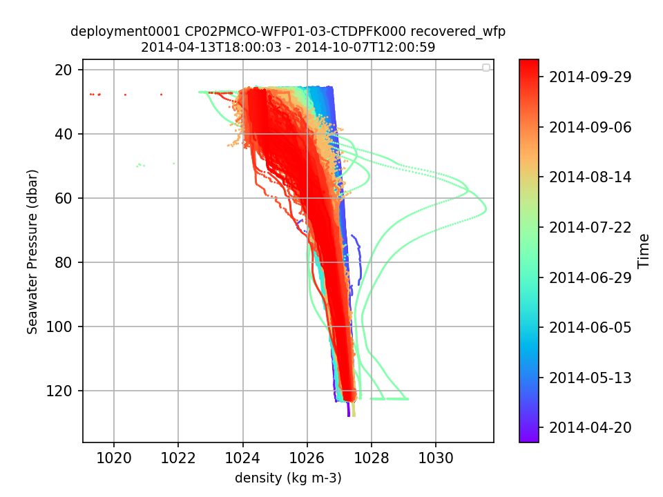 |
|
CP02PMCO-WFP01 |
12/6/14, 12:00 AM | 5/2/15, 12:00 AM |
bad data for CTD, DO, FLORT, VEL3D and PAR seen after 15 December 2014 to the end of the deployment. example plot from CTD shown. By Leila Belabbassi, on 3/21/19  |
|
CP02PMCO-WFP01 |
12/6/14, 12:00 AM | 5/2/15, 12:00 AM |
annotation ID 712 should be updated by adding that data quality is bad for this time range. By Leila Belabbassi, on 3/20/19 |
|
CP02PMCO-WFP01-03-CTDPFK000 Deployment: 1 |
9/26/14, 12:00 AM | 9/27/14, 12:00 AM |
suspect data with individual profiles By Leila Belabbassi, on 3/20/19 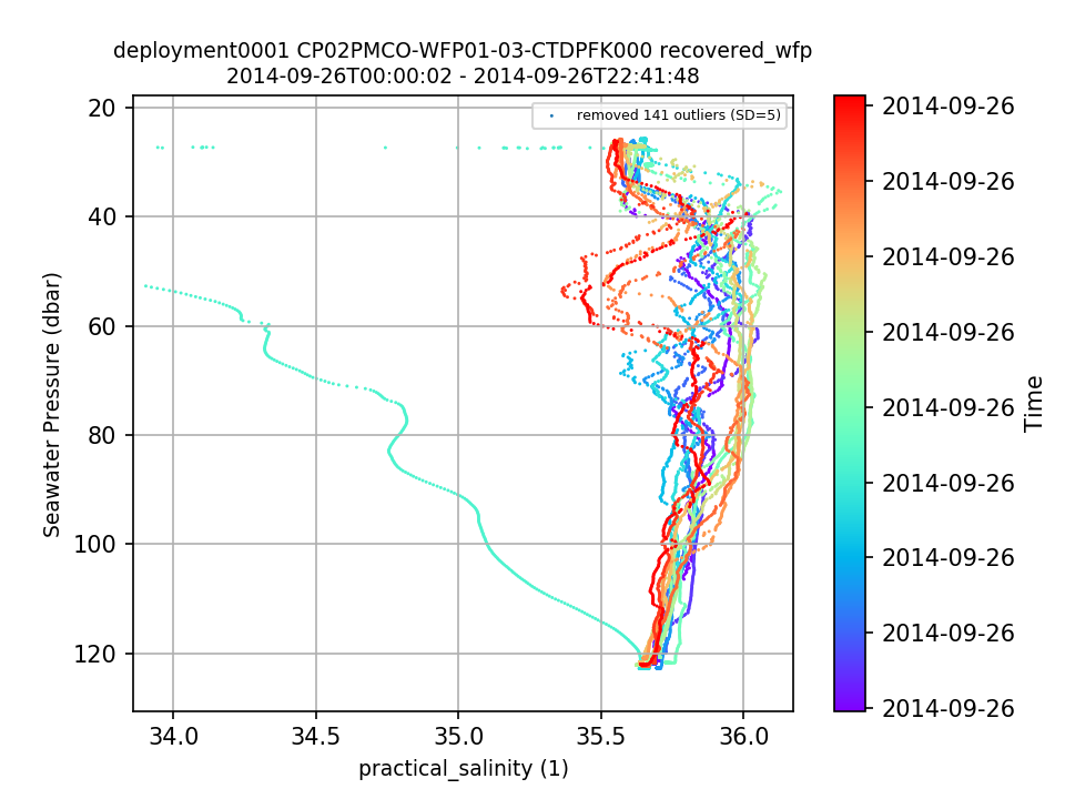 |
|
CP02PMCO-WFP01-03-CTDPFK000 Deployment: 6 |
9/4/16, 12:00 AM | 9/10/16, 12:00 AM |
suspect data with individual profiles By Leila Belabbassi, on 3/19/19 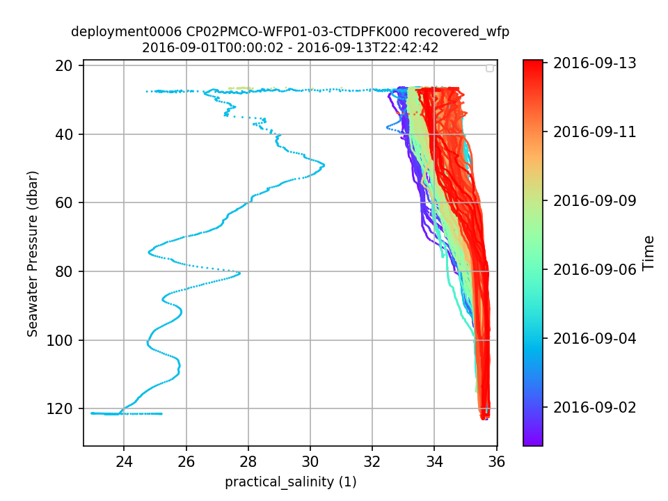 |
|
CP02PMCO-WFP01-03-CTDPFK000 Deployment: 8 |
suspect data profiles By Leila Belabbassi, on 3/20/19 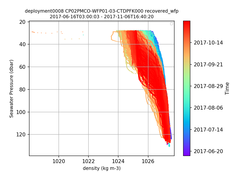 |
||
|
CP02PMCO Deployment: 8 |
Lat and Lon for deployment 8 are very far for what is the platform standard location. Please check? see redmine help desk ticket # 13757 (https://redmine.oceanobservatories.org/issues/13757) By Leila Belabbassi, on 3/19/19 |
||
|
CP01CNPM-WFP01-04-FLORTK000 Deployment: 1 |
total_volume_scattering_coefficient_m-1 sr-1 and optical_backscatter_m-1 show an event in mid March 2018 that need to be investigated further. By Leila Belabbassi, on 3/18/19 |
||
|
CP01CNPM-WFP01-05-PARADK000 |
The PAR measurements at depth greater than 100 dbar are too high [ > 5 - 30 µmol m-1 s-1] resembling the surface data. By Leila Belabbassi, on 3/15/19 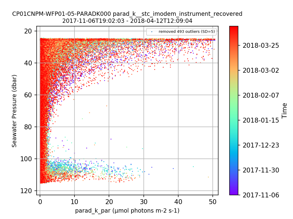 |
||
|
CP01CNPM |
system missing global ranges for all parameters because the platform is not listed in the data_qc_global_range_values.csv By Leila Belabbassi, on 3/15/19 |
||
|
CP01CNPM-WFP01-05-PARADK000 |
The depth recorded in the deployment sheet is 12 m shallower than the maximum depth the profiler is measuring. Is that by design? By Leila Belabbassi, on 3/15/19 |
||
|
CP03ISSM-MFD37-04-DOSTAD000 |
Deployments 4 and 6: By Leila Belabbassi, on 3/12/19 |
||
|
CP01CNPM-WFP01-04-FLORTK000 Deployment: 1 |
pressure record in the data file are all NaNs. lgarzio edit: The pressure coordinate (pressure_depth) is an array of all fill values. This variable should contain valid pressure data. There is another variable in the files called in_ctd_pressure that contains what appears to be valid pressure data. This is the case for every FLORTK on every WFP. https://opendap.oceanobservatories.org/thredds/dodsC/ooi/lgarzio@marine.rutgers.edu/20181218T135235-CP01CNPM-WFP01-04-FLORTK000-recovered_wfp-flort_sample/deployment0001_CP01CNPM-WFP01-04-FLORTK000-recovered_wfp-flort_sample_20171106T190203-20180412T120904.nc.ascii?pressure_depth[0:1:1000],int_ctd_pressure[0:1:1000] By Leila Belabbassi, on 3/6/19 |
||
|
CP03ISSM-MFD37-04-DOSTAD000 Deployment: 7 |
one day of data is missing in the recovered_host data files which is not the case for telemetered data files. By Leila Belabbassi, on 3/8/19 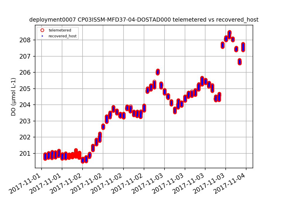 |
||
|
CP03ISSM-MFD37-04-DOSTAD000 Deployment: 4 |
recovered_host DO - Pressure Temp Sal Corrected parameter is missing 5 days of data that are available in the telemetered data. By Leila Belabbassi, on 3/8/19 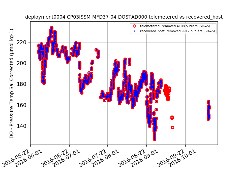 |
||
|
CP03ISSM-MFD37-04-DOSTAD000 |
lon, lat and pressure coordinates are missing from deployment 4 and 6 data files By Leila Belabbassi, on 3/8/19 |
||
|
CP03ISSM-MFD37-04-DOSTAD000 Deployment: 2 |
recovered_host pressure record in the data file is a constant value of 93.8 dbar. This is in agreement with what the CTD file in the CTD folder are reporting: see (https://opendap.oceanobservatories.org/thredds/dodsC/ooi/lgarzio@marine.rutgers.edu/20181212T235133-CP03ISSM-MFD37-03-CTDBPD000-recovered_host-ctdbp_cdef_dcl_instrument_recovered/deployment0002_CP03ISSM-MFD37-03-CTDBPD000-recovered_host-ctdbp_cdef_dcl_instrument_recovered_20150509T010502.785000-20150509T010502.785000.nc.ascii?pressure[0:1:0]) Telemetered data are also missing. There are data in the recovered_inst CTD folder see: (https://opendap.oceanobservatories.org/thredds/dodsC/ooi/lgarzio@marine.rutgers.edu/20181212T235146-CP03ISSM-MFD37-03-CTDBPD000-recovered_inst-ctdbp_cdef_instrument_recovered/deployment0002_CP03ISSM-MFD37-03-CTDBPD000-recovered_inst-ctdbp_cdef_instrument_recovered_20150509T010501-20151021T183501.nc.ascii?ctdbp_seawater_pressure[0:1:15839]) By Leila Belabbassi, on 3/8/19  |
||
|
CP03ISSM-MFD37-04-DOSTAD000 Deployment: 1 |
pressure record has outliers at the beginning of the record that threw off the mean By Leila Belabbassi, on 3/7/19 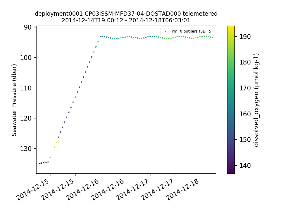 |
||
|
CP03ISSM-MFD37-04-DOSTAD000 Deployment: 6 |
Aug and Oct gaps in data record not annotated in the system. By Leila Belabbassi, on 3/7/19 |
||
|
CP03ISSM-MFD37-04-DOSTAD000 Deployment: 7 |
revise annotation ID # 335. There are data in the system at the start of the deployment. By Leila Belabbassi, on 3/7/19 |