CTD
- Reference Designator
- CP02PMUI-WFP01-03-CTDPFK000
- Start Depth
- 15
- End Depth
- 70
- Location
- Wire Following Profiler Body
- Current Status
- Review Complete
- M2M Example
- https://ooinet.oceanobservatories.org/api/m2m/12576/sensor/inv/CP02PMUI/WFP01/03-CTDPFK000/metadata
| Method | Data Stream | Content | Type | |
|---|---|---|---|---|
| recovered_wfp | ctdpf_ckl_wfp_instrument_recovered | Data Products | Report M2M Stats | Science |
| recovered_wfp | ctdpf_ckl_wfp_metadata_recovered | Metadata | Report M2M | Engineering |
| telemetered | ctdpf_ckl_wfp_instrument | Data Products | Report M2M Stats | Science |
| telemetered | ctdpf_ckl_wfp_metadata | Metadata | Report M2M | Engineering |
| Metadata | Start Date | End Date | Comment |
|---|---|---|---|
|
CP02PMUI-WFP01-03-CTDPFK000 |
Comparisons with the shipboard CTD casts were done for D0002, R0002, D0003, D0005, R0005, D0006, R0006, D0007, R0007, D0008, R0008, D0009, R0009. The profile comparisons mostly don't match. See attached plots for details. Comparison to the shipboard bottle data is outside the scope of this project. By Lori Garzio, on 3/13/19 |
||
|
CP02PMUI-WFP01-03-CTDPFK000 Deployment: 3 |
Annotation ID 725 should be updated to say that no data are available (not only telemetered data) By Lori Garzio, on 8/22/19 |
||
|
CP02PMUI-WFP01-03-CTDPFK000 Deployment: 6 |
3/1/16, 12:00 AM | 5/21/16, 12:00 PM | |
|
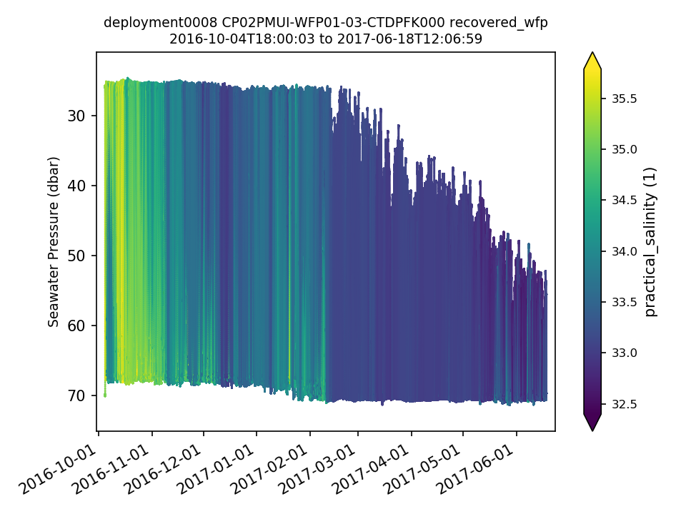
CP02PMUI-WFP01-03-CTDPFK000 Deployment: 8 |
5/1/17, 12:00 AM | 6/18/17, 12:07 PM |
| Metadata | Start Date | End Date | Comment |
|---|---|---|---|
|
CP02PMUI-WFP01 Method: telemetered |
12/9/13, 7:00 PM | 4/11/14, 6:37 PM |
No telemetered data available because the surface buoy went adrift . Id: 723 By: leila |
|
CP02PMUI-WFP01 Method: telemetered |
7/21/14, 6:36 AM | 7/31/14, 12:30 AM |
MMP failed. No telemetered data are available. The list of files got too long for the inductive modem and time run out to search and send out the data files via telemetry. Id: 724 By: leila |
|
CP02PMUI-WFP01 Method: telemetered |
10/20/14, 6:36 AM | 12/13/14, 7:00 PM |
No telemetered data available because surface buoy broke free.
Id: 725
By: leila
|
|
CP02PMUI-WFP01 |
4/3/16, 9:35 AM | 5/21/16, 8:00 AM |
Wire Following Profiler profiling erratically and sometimes unable to reach the programmed top depth. Id: 606 By: leila |
|
CP02PMUI |
4/3/16, 9:35 AM | 5/21/16, 8:00 AM |
No telemetered data available because surface buoy broke free. Id: 116 By: leila |
|
CP02PMUI-WFP01 |
2/13/17, 1:08 AM | 6/7/17, 8:08 AM |
Wire Following Profiler profiling erratically and sometimes unable to reach the programmed top depth. Id: 607 By: leila |
|
CP02PMUI |
2/13/17, 1:08 AM | 6/7/17, 8:08 AM |
No telemetered data available because the surface buoy went adrift after a series of strong winter storms. Id: 236 By: leila |
|
CP02PMUI |
3/3/18, 1:00 AM | 4/11/18, 5:49 PM |
Deployment 10: Surface buoy went adrift following a large storm on 02 March 2018.
Id: 1365
By: leila
|
|
CP02PMUI-WFP01 |
3/23/19, 8:00 PM | 4/18/19, 8:00 PM |
Deployment 12: Erratic profiles 2019-03-24 through 2019-03-26 and 2019-04-03 onward until recovery. Id: 1624 By: cdobson |
|
CP02PMUI-WFP01 |
11/30/19, 7:00 PM | 6/13/20, 12:02 PM |
Deployment 14: Starting 11/29/2019 WFP01 was unable to complete full range descending profiles. Id: 1829 By: cdobson |
|
CP02PMUI-WFP01 |
12/31/19, 7:00 PM | 6/13/20, 12:02 PM |
Deployment 14: Due to a clock rollover issue, all WFPs have ceased sampling on 1/1/2020. No WFP data are being collected after this date. A resolution is being researched by the vendor. Id: 1883 By: cdobson |

