CTD (30 m)
- Reference Designator
- GP03FLMA-RIM01-02-CTDMOG040
- Start Depth
- 30
- End Depth
- 30
- Location
- Fixed on Inductive Wire
- Current Status
- Review Complete
- M2M Example
- https://ooinet.oceanobservatories.org/api/m2m/12576/sensor/inv/GP03FLMA/RIM01/02-CTDMOG040/metadata
| Method | Data Stream | Content | Type | |
|---|---|---|---|---|
| recovered_host | ctdmo_ghqr_offset_recovered | Offset Data | Report M2M | Engineering |
| recovered_host | ctdmo_ghqr_sio_mule_instrument | Data Products | Report M2M Stats | Science |
| recovered_inst | ctdmo_ghqr_instrument_recovered | Data Products | Report M2M Stats | Science |
| telemetered | ctdmo_ghqr_sio_mule_instrument | Data Products | Report M2M Stats | Science |
| telemetered | ctdmo_ghqr_sio_offset | Offset Data | Report M2M | Engineering |
| Deployment | Cruise | Start Date | Stop Date | Mooring Asset | Node Asset | Sensor Asset | Latitude | Longitude | Deployment Depth | Water Depth |
|---|---|---|---|---|---|---|---|---|---|---|
| 1 Review | MV-1309 | 07/21/2013 | 06/15/2014 | CGMGP-03FLMA-00001 | CGINS-CTDMOG-10257 | 49.9795 | -144.254 | 28 | 4127 | |
| 2 Review | MV-1404 | 06/17/2014 | 06/05/2015 | CGMGP-03FLMA-00002 | CGINS-CTDMOG-11642 | 49.9775 | -144.246 | 28 | 4237 | |
| 3 Review | TN-323 | 06/06/2015 | 06/28/2016 | CGMGP-03FLMA-00003 | CGINS-CTDMOG-10219 | 49.9767 | -144.246 | 48 | 4127 | |
| 4 Review | RB-16-05 | 07/01/2016 | 07/18/2017 | CGMGP-03FLMA-00004 | CGINS-CTDMOG-11637 | 49.9743 | -144.24 | 4127 | ||
| 5 Review | SR17-10 | 07/13/2017 | 07/27/2018 | CGMGP-03FLMA-00005 | CGINS-CTDMOG-13421 | 50.0229 | -144.361 | 4096 | ||
| 6 Review | SR1811 | 07/23/2018 | 09/29/2019 | CGMGP-03FLMA-00006 | CGINS-CTDMOG-13644 | 49.9761 | -144.246 | 4123 | ||
| 7 Review | SKQ201920S | 09/29/2019 | CGMGP-03FLMA-00007 | CGINS-CTDMOG-10216 | 50.0227 | -144.361 | 4103 |
| Metadata | Start Date | End Date | Comment |
|---|---|---|---|
|
GP03FLMA |
7/1/16, 1:07 AM | 7/27/18, 10:14 PM |
Deployments 4 and 5 don't have deployment depths defined in asset management. By Lori Garzio, on 1/3/19 |
|
GP03FLMA-RIM01-02-CTDMOG040 Deployment: 2 |
6/17/14, 6:00 AM | 6/5/15, 12:00 AM |
recovered_inst data are not available for download from uFrame. There is an entry in the ingest csv indicating that the raw data file is available. This should be investigated and the recovered_inst data should be made available for download (or the system should have an annotation indicating why the recovered_inst data are not available). By Lori Garzio, on 1/4/19 |
|
GP03FLMA Deployment: 5 |
7/13/17, 11:00 PM | 7/27/18, 10:14 PM |
The mooring was deployed 9 - 10 km from the location of the previous 4 deployments of this mooring. If this location is correct, the platform should be annotated to inform the users as to why the deployment location changed. By Lori Garzio, on 1/4/19 |
|
GP03FLMA-RIM01-02-CTDMOG040 Deployment: 5 |
10/28/17, 5:15 AM | 11/5/17, 1:00 PM |
There is a data gap in the recovered_inst data stream from 2017-10-28T05:15:01 to 2017-11-05T13:00:01, however these data are available in the recovered_host data stream. The recovered_inst data should be filled in. See Redmine ticket 13752. By Lori Garzio, on 1/4/19 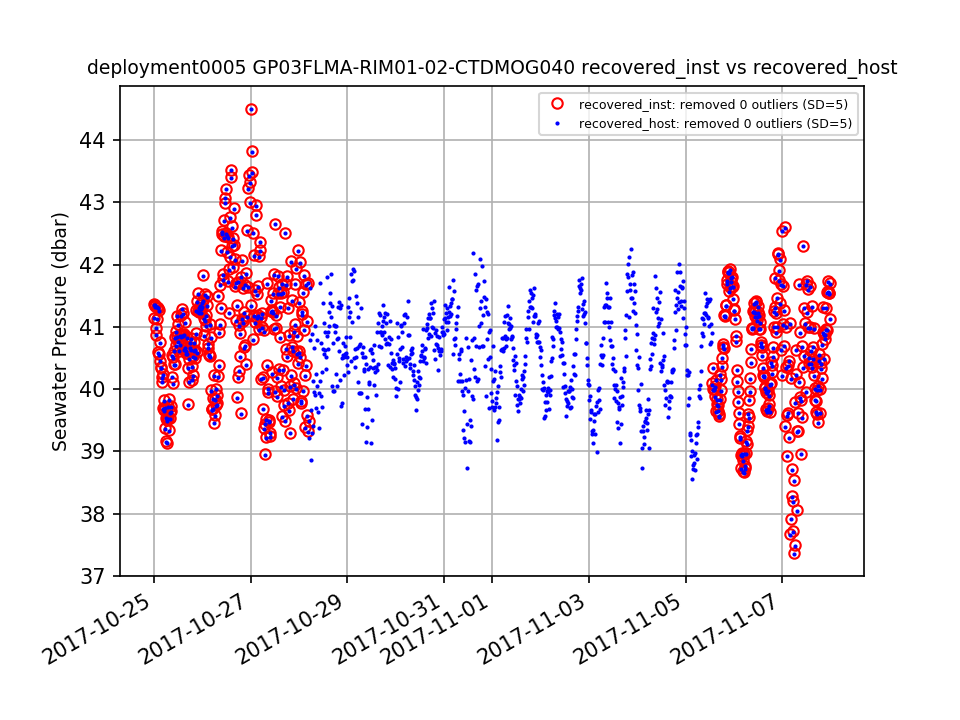 |
| Metadata | Start Date | End Date | Comment |
|---|---|---|---|
|
GP03FLMA |
7/21/13, 6:44 PM | 6/14/14, 8:00 PM |
Deployment 1: Mooring was deployed 10-15m shallower than planned. Telemetered data are not available for this deployment. Id: 150 By: lgarzio |
|
GP03FLMA-RIM01-02-CTDMOG040 |
6/17/14, 2:00 AM | 6/4/15, 8:00 PM |
Deployment 2: Upon recovery, a shield that guards the sensor and holds the anti-fouling was missing. Id: 582 By: lgarzio |
|
GP03FLMA |
6/17/14, 2:00 AM | 6/4/15, 8:00 PM |
Deployment 2: Mooring was deployed 15-20m shallower than planned. Upon recovery of platform, biofouling was apparent on shallow CTDs. Id: 151 By: lgarzio |
|
GP03FLMA |
6/6/15, 6:40 PM | 6/28/16, 3:10 PM |
Deployment 3: Mooring was deployed 10-15m deeper than planned. Id: 152 By: lgarzio |
|
GP03FLMA |
6/30/16, 9:07 PM | 7/18/17, 11:13 AM |
Deployment 4: Mooring was deployed 10-15m deeper than planned. Id: 153 By: lgarzio |
|
GP03FLMA |
7/13/17, 7:00 PM | 7/27/18, 6:14 PM |
Deployment 5: Telemetered data are not available for this deployment because gliders were not deployed. Id: 141 By: lgarzio |