Spectral Irradiance
- Reference Designator
- CE07SHSM-RID26-08-SPKIRB000
- Start Depth
- 7
- End Depth
- 7
- Location
- Near Surface Instrument Frame
- Current Status
- Review Complete
- M2M Example
- https://ooinet.oceanobservatories.org/api/m2m/12576/sensor/inv/CE07SHSM/RID26/08-SPKIRB000/metadata
| Method | Data Stream | Content | Type | |
|---|---|---|---|---|
| recovered_host | spkir_abj_dcl_instrument_recovered | Data Products | Report M2M Stats | Science |
| telemetered | spkir_abj_dcl_instrument | Data Products | Report M2M Stats | Science |
| Deployment | Cruise | Start Date | Stop Date | Mooring Asset | Node Asset | Sensor Asset | Latitude | Longitude | Deployment Depth | Water Depth |
|---|---|---|---|---|---|---|---|---|---|---|
| 1 Review | OC1503D | 04/05/2015 | 09/23/2015 | CGMCE-07SHSM-00001 | CGINS-SPKIRB-00242 | 46.9861 | -124.566 | 7 | 87 | |
| 2 Review | OC1510A | 10/13/2015 | 05/13/2016 | CGMCE-07SHSM-00002 | CGINS-SPKIRB-00232 | 46.9875 | -124.569 | 7 | 87 | |
| 3 Review | TN-342 | 05/05/2016 | 09/27/2016 | CGMCE-07SHSM-00003 | CGINS-SPKIRB-00248 | 46.9895 | -124.569 | 7 | 87 | |
| 4 Review | AT37-03 | 09/20/2016 | 04/13/2017 | CGMCE-07SHSM-00004 | CGINS-SPKIRB-00254 | 46.9859 | -124.566 | 7 | 87 | |
| 5 Review | SKQ201704S | 04/11/2017 | 10/06/2017 | CGMCE-07SHSM-00005 | CGINS-SPKIRB-00250 | 46.9882 | -124.567 | 7 | 89 | |
| 6 Review | SKQ201715S | 10/03/2017 | 03/29/2018 | CGMCE-07SHSM-00006 | CGINS-SPKIRB-00298 | 46.9852 | -124.564 | 7 | 87 | |
| 7 Review | SKQ201808S | 03/25/2018 | 09/20/2018 | CGMCE-07SHSM-00007 | CGINS-SPKIRB-00295 | 46.9881 | -124.568 | 7 | 87 | |
| 8 Review | SR1813 | 09/18/2018 | 04/26/2019 | CGMCE-07SHSM-00008 | CGINS-SPKIRB-00231 | 46.9835 | -124.564 | 7 | 87 | |
| 9 Review | SKQ201910S | 04/24/2019 | 10/12/2019 | CGMCE-07SHSM-00009 | CGINS-SPKIRB-00249 | 46.9878 | -124.568 | 7 | 87 | |
| 10 Review | SKQ201921S | 10/10/2019 | CGMCE-07SHSM-00010 | CGINS-SPKIRB-00243 | 46.9841 | -124.566 | 7 | 87 |
| Metadata | Start Date | End Date | Comment |
|---|---|---|---|
|
CE07SHSM-RID26-08-SPKIRB000 |
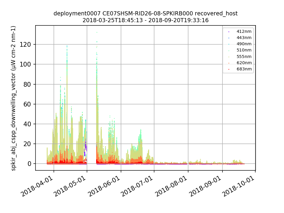
A substantial percentage (between 19-43%) of data are outside of global ranges for every deployment. Zooming in on the x-axis in the plots shows that all of the values that are outside of global ranges are negative. By Lori Garzio, on 7/12/19 |
||
|
CE07SHSM-RID26-08-SPKIRB000 |
There is no pressure variable in the .nc files. This should be a coordinate. By Lori Garzio, on 7/12/19 |
||
|
CE07SHSM-RID26-08-SPKIRB000 Deployment: 4 |
11/15/16, 12:00 AM | 4/13/17, 11:22 PM | |
|
CE07SHSM-RID26-08-SPKIRB000 Deployment: 7 |
7/1/18, 12:00 AM | 9/20/18, 8:04 PM |
| Metadata | Start Date | End Date | Comment |
|---|---|---|---|
|
CE07SHSM |
12/1/17, 9:35 AM | 3/25/18, 3:09 PM |
Data loss due to a power system failure. The mooring stopped receiving power from photo voltaic panel 1 of 4 on Nov-2. By Nov-20, the mooring stopped receiving power from two more solar panels (PV2 & PV4) and one of two wind turbines (WT2). This indicates the Power System Controller (PSC) they connect to is failing. Mooring components will be shut down as the mooring loses the ability to recharge its batteries.
Id: 1237
By: crisien
|
|
CE07SHSM-RID26-08-SPKIRB000 Method: telemetered Stream: spkir_abj_dcl_instrument |
11/30/18, 7:00 PM | 2/21/19, 1:33 PM |
Signal appears to decreasing in a manner that would suggest biofouling. Data from this time-period should be considered as suspect.
Id: 1567
By: wingardc
|
|
CE07SHSM-RID26-08-SPKIRB000 Method: telemetered Stream: spkir_abj_dcl_instrument |
2/21/19, 1:33 PM |
Data suggests the sensor has become fouled. Readings essentially flat-lined beginning around December 31, 2018. Sensor was powered off February 21, 2019. No further data will be collected for the remainder of the deployment.
Id: 1566
By: wingardc
|
|
|
CE07SHSM-RID26-08-SPKIRB000 |
10/10/19, 5:07 PM |
The use of UV lamps has been implemented for biofouling mitigation on this instrument as of 2019-10-10T21:07:00Z. Id: 2124 By: wingardc |
|
|
CE07SHSM Method: telemetered |
5/13/20, 6:40 PM |
Due to a bug in the mooring telemetry system, data during this time range was not telemetered to shore. It was recorded on the mooring and instruments and will be available in the recovered data streams.
Id: 2185
By: wingardc
|

