Photosynthetically Available Radiation

Reference Designator
CP05MOAS-A6264-06-PARADN000
Start Depth
0
End Depth
600
Location
Current Status
Will Not Review
Class
PARAD (Photosynthetically Available Radiation)
Series
PARAD-N
Science Discipline
Biological
Make
Biospherical Instruments
Model
QSP-2150
M2M Example
https://ooinet.oceanobservatories.org/api/m2m/12576/sensor/inv/CP05MOAS/A6264/06-PARADN000/metadata
Method Data Stream Content Type
recovered_host parad_n_auv_instrument_recovered Data Products Report M2M Stats Science
Deployment Cruise Start Date Stop Date Mooring Asset Node Asset Sensor Asset Latitude Longitude Deployment Depth Water Depth
1 Review AT-27 05/08/2015 05/12/2015 CGVCP-05MOAS-00000 CGVEH-AUVPNR-06264 CGINS-PARADN-50170 40.6426 -70.4317
2 Review AR-04 05/30/2016 05/31/2016 CGVCP-05MOAS-00000 CGVEH-AUVPNR-06264 CGINS-PARADN-50170 40.221 -70.9122
3 Review AR-08 10/14/2016 10/16/2016 CGVCP-05MOAS-00000 CGVEH-AUVPNR-06264 CGINS-PARADN-50170 40.2025 -71.1014
4 Review AR-24 11/02/2017 11/03/2017 CGVCP-05MOAS-00000 CGVEH-AUVPNR-06264 CGINS-PARADN-50170 39.9232 -70.8961
6 Review WJ20180423 04/24/2018 04/24/2018 CGVCP-05MOAS-00000 CGVEH-AUVPNR-06264 CGINS-PARADN-50266 39.9184 -70.8985
7 Review AR-31 10/30/2018 10/31/2018 CGVCP-05MOAS-00000 CGVEH-AUVPNR-06264 CGINS-PARADN-50266 39.9196 -70.9106
8 Review WJ20190228 03/01/2019 03/01/2019 CGVCP-05MOAS-00000 CGVEH-AUVPNR-06264 CGINS-PARADN-50266 39.9275 -70.9325
9 Review AR-34 04/05/2019 04/07/2019 CGVCP-05MOAS-00000 CGVEH-AUVPNR-06264 CGINS-PARADN-50266 39.9203 -70.9071
10 Review AR-34 04/10/2019 04/11/2019 CGVCP-05MOAS-00000 CGVEH-AUVPNR-06264 CGINS-PARADN-50266 39.9169 -70.906
11 Review WJ20190617 06/18/2019 06/19/2019 CGVCP-05MOAS-00000 CGVEH-AUVPNR-06264 CGINS-PARADN-50180 39.9306 -70.9017
12 Review WJ20190709 07/10/2019 07/11/2019 CGVCP-05MOAS-00000 CGVEH-AUVPNR-06264 CGINS-PARADN-50180 40.3418 -70.89
13 Review WJ20190709 07/11/2019 07/11/2019 CGVCP-05MOAS-00000 CGVEH-AUVPNR-06264 CGINS-PARADN-50180 40.3378 -70.905
14 Review AR-39 09/30/2019 09/30/2019 CGVCP-05MOAS-00000 CGVEH-AUVPNR-06264 CGINS-PARADN-50180 39.9207 -70.7643
Metadata Start Date End Date Comment
CP05MOAS

Bad altimeter pings are apparent in many deployments of the coastal gliders. A few example plots are attached - m_water_depth plotted as semi-transparent bathymetry.

By Lori Garzio, on 5/10/19

CP05MOAS

Glider optodes typically exhibit a sensor lag of 20-25 seconds. Example attached of several segments with consecutive down and up casts for CP05MOAS-GL335-04-DOSTAM000 on 10/26/2015 showing a typical measurement time lag. Profiles should be analyzed for individual time lags and data should be adjusted. OOI doesn't necessarily need to make the adjustment but users should be aware of the issue.

By Lori Garzio, on 5/15/19
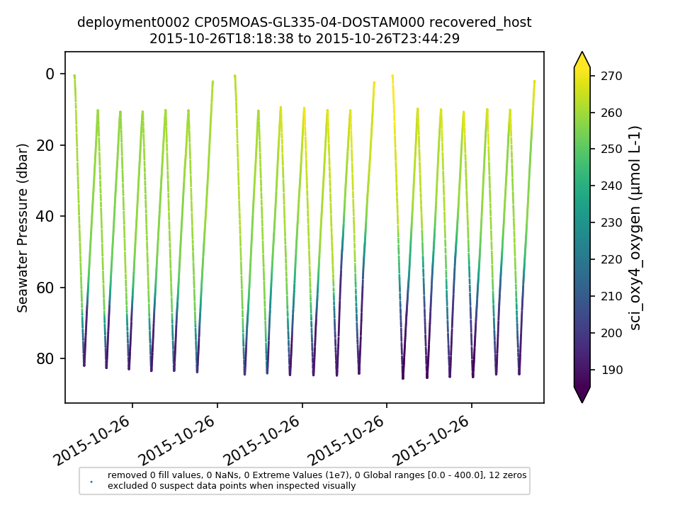
New Note

No annotations yet.