Single Point Velocity Meter
- Reference Designator
- CE02SHSM-RID26-04-VELPTA000
- Start Depth
- 7
- End Depth
- 7
- Location
- Near Surface Instrument Frame
- Current Status
- Review Complete
- M2M Example
- https://ooinet.oceanobservatories.org/api/m2m/12576/sensor/inv/CE02SHSM/RID26/04-VELPTA000/metadata
| Method | Data Stream | Content | Type | |
|---|---|---|---|---|
| recovered_host | velpt_ab_dcl_diagnostics_metadata_recovered | Diagnostics Metadata | Report M2M | Engineering |
| recovered_host | velpt_ab_dcl_diagnostics_recovered | Diagnostics Data | Report M2M | Engineering |
| recovered_host | velpt_ab_dcl_instrument_recovered | Data Products | Report M2M Stats | Science |
| recovered_inst | velpt_ab_diagnostics_metadata_recovered | Diagnostics Metadata | Report M2M | Engineering |
| recovered_inst | velpt_ab_diagnostics_recovered | Diagnostics Data | Report M2M | Engineering |
| recovered_inst | velpt_ab_instrument_metadata_recovered | Metadata | Report M2M | Engineering |
| recovered_inst | velpt_ab_instrument_recovered | Data Products | Report M2M Stats | Science |
| telemetered | velpt_ab_dcl_diagnostics | Diagnostics Data | Report M2M | Engineering |
| telemetered | velpt_ab_dcl_diagnostics_metadata | Diagnostics Metadata | Report M2M | Engineering |
| telemetered | velpt_ab_dcl_instrument | Data Products | Report M2M Stats | Science |
| Deployment | Cruise | Start Date | Stop Date | Mooring Asset | Node Asset | Sensor Asset | Latitude | Longitude | Deployment Depth | Water Depth |
|---|---|---|---|---|---|---|---|---|---|---|
| 1 Review | OC1503D | 04/02/2015 | 09/22/2015 | CGMCE-02SHSM-00001 | CGINS-VELPTA-11780 | 44.6383 | -124.304 | 7 | 80 | |
| 2 Review | OC1510A | 10/07/2015 | 05/16/2016 | CGMCE-02SHSM-00002 | CGINS-VELPTA-11814 | 44.6354 | -124.303 | 7 | 82 | |
| 3 Review | TN-342 | 05/17/2016 | 09/28/2016 | CGMCE-02SHSM-00003 | CGINS-VELPTA-11823 | 44.6357 | -124.304 | 7 | 80 | |
| 4 Review | AT37-03 | 09/26/2016 | 04/22/2017 | CGMCE-02SHSM-00004 | CGINS-VELPTA-11775 | 44.6393 | -124.304 | 7 | 80 | |
| 5 Review | SKQ201704S | 04/20/2017 | 10/15/2017 | CGMCE-02SHSM-00005 | CGINS-VELPTA-08381 | 44.6358 | -124.304 | 7 | 81 | |
| 6 Review | SKQ201715S | 10/10/2017 | 04/04/2018 | CGMCE-02SHSM-00006 | CGINS-VELPTA-11775 | 44.6393 | -124.304 | 7 | 80 | |
| 7 Review | SKQ201808S | 04/03/2018 | 09/25/2018 | CGMCE-02SHSM-00007 | CGINS-VELPTA-08381 | 44.6357 | -124.304 | 7 | 80 | |
| 8 Review | SR1813 | 09/22/2018 | 04/21/2019 | CGMCE-02SHSM-00008 | CGINS-VELPTA-12703 | 44.6395 | -124.301 | 7 | 80 | |
| 9 Review | SKQ201910S | 04/19/2019 | 10/22/2019 | CGMCE-02SHSM-00009 | CGINS-VELPTA-11823 | 44.6356 | -124.304 | 7 | 80 | |
| 10 Review | SKQ201921S | 10/20/2019 | CGMCE-02SHSM-00010 | CGINS-VELPTA-11774 | 44.6396 | -124.303 | 7 | 80 |
| Metadata | Start Date | End Date | Comment |
|---|---|---|---|
|
CE02SHSM-RID26-04-VELPTA000 |
15-29% of the data points collected during all deployments are when the instrument is tilted too far ( has pitch or roll >20 degrees). Example plot attached By Lori Garzio, on 8/14/19  |
||
|
CE02SHSM-RID26-04-VELPTA000 Deployment: 6 |
10/10/17, 2:21 AM | 10/20/17, 12:00 AM |
Suspect data at the beginning of deployment 6. By Lori Garzio, on 8/14/19 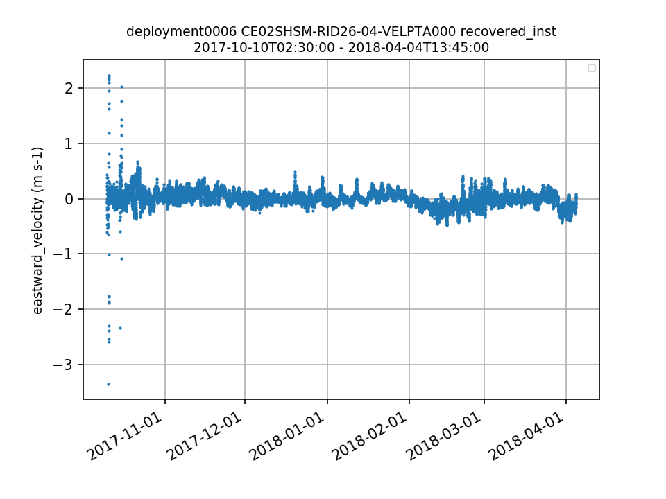 |
| Metadata | Start Date | End Date | Comment |
|---|---|---|---|
|
CE02SHSM-RID26-04-VELPTA000 |
4/2/15, 4:15 PM |
According to the manufacturer, data are suspect when the instrument is tilted more than 20 degrees (measured by pitch and roll). Id: 798 By: lgarzio |
|
|
CE02SHSM-RID26 |
5/8/17, 8:00 PM | 5/13/17, 8:00 PM |
Communications with instruments on the NSIF for CE02SHSM are offline. Monitoring current draws to the NSIF shows a pattern of increased and expected current draws every 15 minutes, corresponding to the instrument sampling schedules. This suggests that the DCLs and attached instruments are still operating, but communications to the system are offline, reason unknown. Affected systems are: CPM2, DCL26: ADCPT, VELPT, PHSEN, uCSPP (acoustic modem communications), NUTNR, SPKIR, DCL27: OPTAA, FLORT, DOSTA, CTDBP. NSIF communicated starting again early on the 14th. Logs from NSIF systems indicate that the systems and instruments are still working, pointing to a communications issue between the NSIF and the surface buoy telemetry system.
Id: 865
By: michaesm
|
|
CE02SHSM-RID26 Method: telemetered |
11/22/19, 3:45 PM | 1/7/20, 1:30 PM |
Due to reduced power on the mooring (limited recharging of the batteries with light winds and sea lions blocking the solar panels), we have had to reduce the operating schedule of the 7 meter platform. Normally we run the system continuously, but have reduced that schedule to hourly. Id: 1835 By: wingardc |
|
CE02SHSM-RID26 Method: telemetered |
1/7/20, 7:00 PM | 1/13/20, 1:45 PM |
Due to an intermittent communications issue with DCL26, we are not receiving data from the instruments consistently. We expect the data to be available upon mooring recovery.
Id: 1890
By: wingardc
|
|
CE02SHSM-RID26 Method: telemetered |
1/13/20, 1:45 PM |
During a large storm event on 2020-01-11, power from the wind turbines was lost. This is the primary means of recharging the battery system on the mooring. With the loss of recharging power, we have had to implement a conservative power model. These systems and instruments have been disabled for the foreseeable future, and no further data will collected from them.
Id: 1902
By: wingardc
|